Altimetry Mapping Procedure for Global River Models
Future generations are increasingly at risk from freshwater shortage, therefore precise water resource monitoring is crucial to comprehending availability and demand trends. Although global hydrodynamic models are capable of simulating the dynamics of continental surface water, they need to be calibrated using observable data such as surface area, river discharge, and water surface elevation. However, the limited network of stream gauges frequently proves insufficient for this purpose. Over the past thirty years, satellite altimetry has become a viable option. Depending on the equipment and environment, it may provide relatively accurate observations of terrestrial water levels with errors ranging from centimeters to decimeters. These satellites utilize radar or laser travel times to determine the elevation of the water’s surface, but the method necessitates complex modifications for tidal and atmospheric conditions. Multiple missions, ranging from TOPEX/Poseidon to the more recent Sentinel series, have produced significant data via “virtual stations” when satellite tracks meet aquatic bodies, allowing for sequential water level readings with each pass. However, this technique confronts substantial challenges: river features, surrounding geography, and land cover all have an impact on measurement accuracy that is difficult to anticipate. Perhaps more problematically, the discrepancy between virtual station locations and actual river networks in hydrodynamic models can induce significant biases, especially when rivers have continuous slopes and model grids produce fake discontinuities. We address this limitation by introducing AltiMaP, an automated mapping procedure designed to better align satellite observations with model river networks, potentially improving our ability to validate and calibrate large-scale hydrodynamic models on a global scale.
Data Requirements for AltiMaP
Satellite Altimetry Dataset
The system needs a comprehensive list of satellite altimetry observations that includes the initial virtual station coordinates and complete time series of water surface elevation measurements. This allows the algorithm to calculate mean observations and understand temporal patterns at each location.
High-Resolution Hydrography Information
Detailed hydrographic data serves as the foundation for accurate mapping, encompassing flow direction maps, land-water classification boundaries, upstream drainage area calculations, and other hydrological characteristics. This fine-scale information helps bridge the gap between satellite observations and model representations.
Coarse-Resolution River Network
A generalized river map at coarser resolution provides the framework for generating model-compatible parameters and establishing connections between high-resolution hydrographic details and the simplified river networks used in large-scale hydrodynamic models.
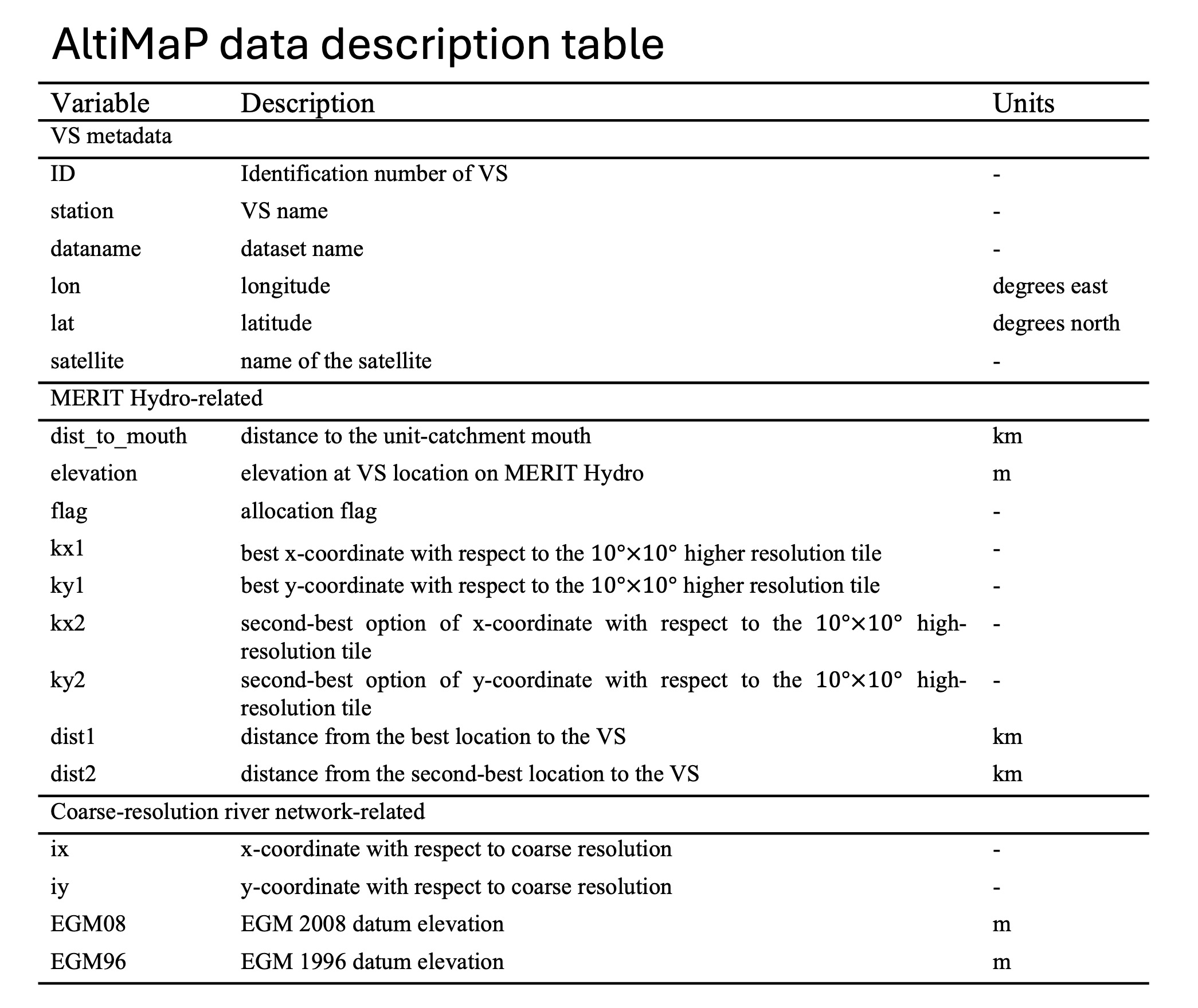
Output variables of AltiMaP
The AltiMaP dataset provides comprehensive information for each virtual station (VS), with variables organized into three main categories. The VS metadata includes basic identifiers like station ID, name, coordinates, and the associated satellite mission. More technically significant are the parameters linking each VS to the high-resolution MERIT Hydro river network - these can be adapted for other river datasets using the flagging and allocation methods described in the study, with an additional flag increment of 100 for biased stations. A particularly useful metric is the distance from each mapped VS to its unit-catchment river mouth, which helps explain discrepancies between simulated and observed water surface dynamics. The system identifies both primary and secondary candidate locations for VS placement along the MERIT Hydro river centerline (though this isn’t available for single-channel rivers), reporting the geometric distances from the original VS position to these options. River width calculations at each VS location use satellite-based water masks combined with flow direction data. Finally, the dataset includes coarse-resolution variables for integration with large-scale hydrodynamic models, providing x-y coordinates for the coarse-resolution river map and elevation references from both EGM08 and EGM96 gravitational models. The complete dataset appears to offer researchers a ready-to-use resource for improving satellite altimetry integration in hydrodynamic modeling applications.
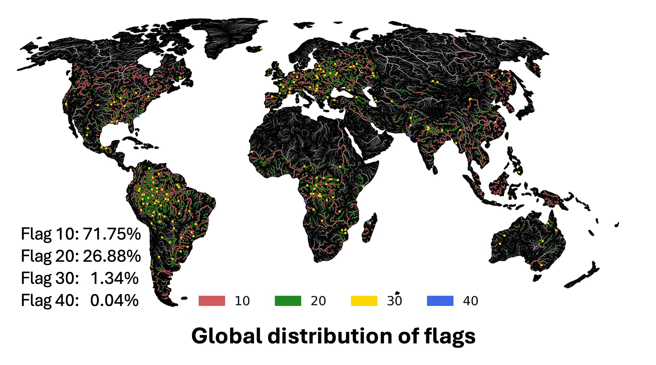
Global distribution of flags
The global distribution of flags shows that virtual stations initially located on river channels are the most common, making up about three-quarters of all stations. Stations on land near single-channel rivers account for roughly a quarter of the total, while those near multi-channel rivers and ocean pixels represent much smaller fractions at around 1% and less than 0.1%, respectively. These patterns indicate a fairly even global spread for the two main categories, with major river systems generally displaying good alignment between station locations and river networks. Ocean- adjacent stations tend to be near river mouths across various continents, and multi-channel river stations mainly cluster in midstream areas with complex channel networks. Analysis of upstream catchment areas shows that ocean-adjacent stations predictably have the largest median catchment sizes due to their downstream locations, while land stations near single-channel rivers have the smallest medians, suggesting upstream placement. River channel stations fall between these extremes. Elevation patterns reveal that land-based stations (both single- and multi-channel types) are usually at higher elevations, with median values ranging roughly from 110 to 150 meters, compared to river channel stations. Ocean- adjacent stations typically have very low elevations near sea level, with the overall elevation range extending from sea level up to nearly 5000 meters. River width distributions vary widely: land stations near single- channel rivers have the narrowest median widths at about 40 meters with low variation; ocean- adjacent stations have the widest median widths at over 200 meters with substantial variation due to major downstream river influences; river channel stations have similar median widths to ocean stations but with less variation; and multi- channel river stations fall between these extremes. The large variations observed reflect the diverse range of river systems represented across each category.
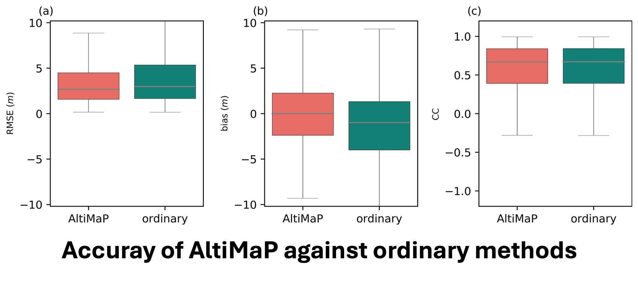
AltiMaP Performance Evaluation
Mapping virtual stations to MERIT Hydro, a high-resolution global river network, proves essential for hydrological modeling applications because it enables flexible integration across various resolution networks, allows determination of critical parameters like elevation differences and distances to catchment outlets, and demonstrates the ability to allocate stations to any river network with similar topology. When AltiMaP’s performance is compared to traditional allocation methods using water surface elevation simulations from CaMa-Flood, the results show that while global-scale root mean square errors (RMSEs) appear to be generally similar between approaches, AltiMaP exhibits superior representation for approximately 18% of virtual stations, compared to only 13% for traditional methods. More importantly, AltiMaP obtains a median RMSE of around 8 meters compared to nearly 9 meters for conventional allocation, demonstrating an 11% increase in accuracy with a lower interquartile range indicating more consistent performance. Although ocean-adjacent stations exhibit slight degradation, multi-channel river stations exhibit the most significant accuracy gains due to better allocation to appropriate river segments, followed by single-channel and river channel stations, which show moderate improvements. The irregular shapes of unit catchments in hydrodynamic models are largely responsible for these performance differences. Even small location deviations can result in target grid misidentification, which can cause water surface elevation deviations ranging from 1 to 15 meters, depending on local topography and river characteristics. This emphasizes the crucial significance of specialized allocation procedures like AltiMaP for optimizing virtual station placement prior to performing water surface elevation comparisons.